Porto Cesareo (1)
The village with golden beaches
To visit in the marina of Porto Cesareo, Lecce, we find the Fish Museum where there are rare species of fish of special interest, the Marine Biology Station and the Thalassographic Museum, which is a collection of environments, stretches of coastline and seabed reconstructed within the museum, to experience and discover the marine heritage of the Ionian coast.
The coast is fronted by countless islets rich in vegetation and fauna, among which Isola Grande or Isola dei Conigli stands out, an islet located a few meters off the coast of Porto Cesareo that attracts many tourists because of its special location. Very close to the coast of Porto Cesareo, the islet can be easily reached by swimming or by private boats or modest fishing boats.
Porto Cesareo has one of the most symbolic local patronal festivals: the feast of Santa Cesarèa, with a sumptuous and spectacular procession on the sea of the statues of the Beata Vergine Maria del Perpetuo Soccorso (Blessed Virgin Mary of Perpetual Help), patron saint of the city of Porto Cesareo, and the statue of the Santa Cesarèa Vergine (Virgin Saint Cesarèa).
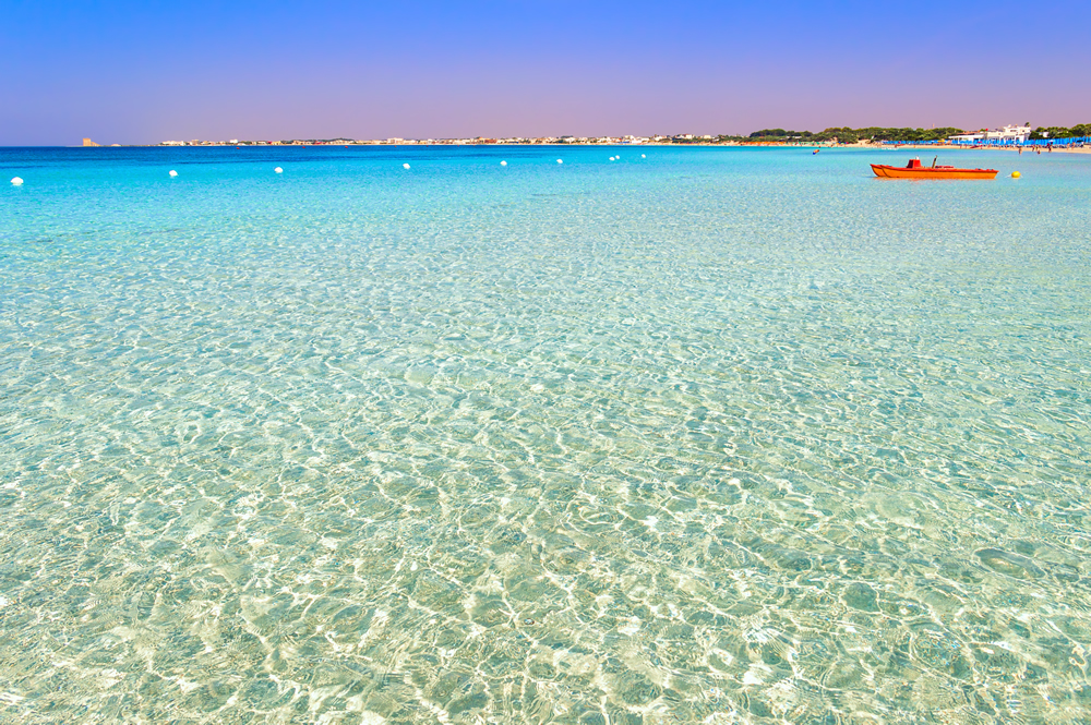
On the border between Lecce and Taranto, on the spectacular Ionian coast, nature has designed an enchanting haunt for sea lovers, an earthly paradise commonly known as Punta Prosciutto Beach in Porto Cesareo. Punta Prosciutto Beach in Porto Cesareo, also known as Palude del Conte, is located near Torre Colimena, set on the border between the provinces of Lecce and Taranto, within the Regional Natural Park, which also includes the Marine Protected Area.
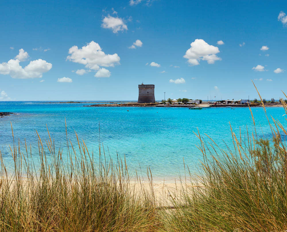
A few kilometers away it is possible to admire the Lecce Baroque, the fortified masserias and many coastal towers, some of them shaped, quadrangular or truncated-pyramidal, built around 1500 to defend the coast from the continuous attacks of the Turks and Pirates. Three of these beautiful towers are known as "the Towers of Porto Cesareo" and are Torre Cesarea, Torre Lapillo and Torre Chianca.
Marine Protected Area (MPA)
The Porto Cesareo Marine Protected Area, established by Decree of the Ministry of the Environment dated December 12, 1997, published in G.U. No. 45 of February 24, 1998, with its 16,654 hectares of protected marine area, is the third largest in Italy.
The Porto Cesareo Marine Protected Area (MPA), established by Decree of the Ministry of the Environment dated December 12, 1997, is a State Marine Reserve, entrusted to a Management Consortium formed by the two municipalities of Porto Cesareo and Nardò, in whose territory the Reserve falls, and the Province of Lecce. The MPA is divided into: 2 Zone A, two Zone B, one Zone C. The Porto Cesareo MPA is the only State Marine Reserve in Salento.
The Porto Cesareo MPA covers 16,654 hectares and 32 km of coastline and involves the coastline of the municipalities of Porto Cesareo and Nardò, both in the province of Lecce, in the eastern part of the Gulf of Taranto, which constitutes the northernmost area of the Ionian Sea.
Porto Cesareo MPA was included in 2011 in the list of Aree Specialmente Protette di Importanza Mediterranea (Specially Protected Areas of Mediterranean Importance) (SPAMI) with the code IT08.
The coast of the marine protected area is bounded to the north by Punta Prosciutto and to the south by Torre Inserraglio, with stretches of sandy coastline alternating with stretches of low, rocky shoreline, rich in islets and outcropping rocks.
This MPA is one of the few that can boast, despite its considerable size, the mapping of the seabed, carried out with methodologies and technologies (geoacoustic systems and ROVs) that provide real information on the type, distribution and extent of habitats. The result of such mapping corresponds to the survey of more than 15 different habitats on the seabed of the MPA, with a very high degree of representativeness of the Mediterranean submerged population.
Three marine SIC sites fall within the MPA: the marine SIC "Porto Cesareo" pSCI (Code: IT9150028) falls within Zone C of the MPA for a total of 21.8 ha; the marine SIC "Palude del Capitano" pSCI (Code: IT9150013) falls within Zone C and Zone B for a total of 1.676 ha.; the marine SIC "Palude del Conte e Dune di Punta Prosciutto" (Code: IT9150027) falls in MPA Zone C for a total of 3659.5 ha) and Zone A for 1047.6 ha.
Also of environmental value, such as to merit protection, is the inland context surrounding the MPA, within which two Regional Protected Areas insist: the Regional Oriented Reserve "Palude del Conte e duna costiera - Porto Cesareo," entrusted to the Municipality of Porto Cesareo, and the Regional Natural Park "Portoselvaggio - Palude del Capitano" entrusted to the Municipality of Nardò, within whose boundaries fall, in all, as many as five terrestrial SIC sites, three of which include the above marine portions.
Recently, the CIESM (Mediterranean Science Commission) proposed the hypothesis of 8 Transboundary Mediterranean Areas to be subjected to joint and coordinated environmental protection among neighboring countries, hence named PEACE PARKS, with the clear objective of conserving biodiversity while promoting international cooperation.
One of the 8 proposed areas, named "North Ionian" (Image 1), entirely includes the Porto Cesareo MPA, along with the Torre Guaceto Reserve and the Albanian and Greek coastal strip.
Purpose
Institutive purposes of the MPA are the protection of the marine environment, the promotion of socio-eco-compatible development, the implementation of environmental education projects aimed at all categories of stakeholders, and the promotion and implementation of scientific research projects. Taking into account the high degree of anthropization of the area, the MPA aims to carry out the management of anthropogenic activities leading to the improvement of the environmental and social quality of the tourism sector and the enhancement of stakeholders' awareness and competence, in order to fulfill its primary goal of environmental protection.
Info and contact information:
Address: Area Marina Protetta Porto Cesareo - Via C. Albano s.n.
Phone: 0833 560144
Fax: 0833 859105
Email: segreteria@areamarinaprotocesareo.it
Official website: Sito ufficiale Area Marina Protetta Porto Cesareo.
Source: www.comune.portocesareo.le.it
Welcome to Trekking Salento
SUNDAY TREKKING, NATURALISTIC, CULTURAL and SPIRITUAL ITINERARIES.
DO YOU WANT TO GET TO KNOW SALENTO IN DEPTH?
Would you like to get together with friends, meet lots of new people and together breathe clean air, socialize and at the same time and in the utmost simplicity, do that healthy and natural physical exercise proper to every living creature?
STS - SpeleoTrekkingSalento
Hiking-cultural association in Lecce - nonprofit, founded on January 1, 1997 by Riccardo Rella, together with Antonio Perulli and Antonio Adamo, after two decades of underground exploration (1975/1995) and speleological activity in Salento karst environments in search of origins.
It was precisely the speleological experience and knowledge of the Territory that prompted Rella to start, first in Salento, the activity of trekking in order to bring to the knowledge of the Salentini, in the simplest and most natural way, that is, with slow movement, the landscape peculiarities that characterize the region.
Hence, all on the road, sharing that healthy movement, free of contraindications, in its simple, fluid, sportsmanship, for the purpose of mental and physical well-being, knowledge and socialization!
With the collaboration of Prof. Rita De Matteis, who joined in 1998, the Association has taken on a more purely cultural slant, with news and insights about the history of the testimonies, around which about 150 trekking circuits currently appear to have been built.
The result of research and hiking experience is the reconstruction of the "Path to Leuca," the historic route taken by pilgrims heading to Terrasanta, or precisely to the perdonanza at the Madonna Maris Stellae, whose Sanctuary, which rises on Punta Meliso, Italy's extreme southern promontory, in a spectacular landscape setting, is believed to have been built by St. Peter himself in 43 A.D., on the ruins of an earlier temple dedicated to Minerva.
SpeleoTrekkingSalento organizes two events each year:
"The Path to Leuca" (to be revived in 2016 for the 13th edition) is a 140-kilometer walk, in six days, from Brindisi to S. Maria de Finibus Terrae, the natural and spiritual convergence of the European Vie Francigene, on olive grove paths, in some stretches scenic, with moments of pause and prayer in the evocative country chapels, entirely frescoed, dedicated to Our Lady; the last stage of this exciting "iter fidei" will be carried out on the first Sunday of May to coincide with the "National Day of the Network of the Paths."
"The Transalentine of the Sun," a 50-kilometer walk, in a single day from morning to sunset, following the path of the Sun, from Otranto, the easternmost city in Italy, to Gallipoli, once a favored oil embarkation port for all of northern Europe. This route is called the “Ponte della fratellanza” (Bridge of Brotherhood), as it unites in an embrace two port cities once united in the struggle against invaders.
The pride of the Association and of Rella, in particular, who is its president, is to have contributed with the word of mouth of thousands of members, who over the past twenty years have taken part in the hiking activity, to make known the most remote recesses of this magical Salento Land, at the time almost literally unknown, with positive implications on tourism and on the enhancement of our artistic preciousness.
Riccardo Rella and Rita De Matteis, in collaboration with the Association, published in 2015 the book-guide "Trekking in Salento," published by Botanica Ornamentale Publishing House in Maglie (www.mauriziocezzi.it - cell. 337/937841) containing twenty-one hiking routes, structured as a ring, accompanied by technical notes, images of satellite tracks with relevant points of interest, detailed descriptions, cultural explanations and a rich photographic apparatus compiled by Prof. Ezio Sarcinella, a well-deserving member of SpeleoTrekkingSalento, author also of the text "La Via dei Pellegrini," a valuable document of the first three editions of the "Path to Leuca" printed by Editrice Salentina. (For contact: Ezio Sarcinella cell. 328/6655489). The text includes photographic documentation produced by the author and valuable graphics, reproductions of original plates by Prof. Marisa Grande.
STS - SpeleoTrekkingSalento
With SpeleoTrekkingSalento itineraries outside the province, canyoning, caving, cultural evenings, interventions in schools, respect for everything and lots of good humor. We started Trekking in Salento to spend Sundays happily together, in complete relaxation, rurality, scent of bush, harmony and simplicity.
STS - SpeleoTrekkingSalento
An open gym in the magical admiration and beauty of the land, in total respect for creation; everything you need to forget, for a while, your daily problems, to live well with yourself and others.
All info at: https://www.trekkingsalento.com
Wreck of the Neuralia
The itinerary, dedicated to more experienced divers and offers a visit to the wreck of the Neuralia, located just over a mile off the coast of Torre Inserraglio, at a depth of 32 meters. The Neuralia is a wreck rich in history: the ship participated in World War I, World War II and the Normandy landings.
The Neuralia's story came to an end on May 1, 1945, at Torre Inserraglio, when on her way to Taranto to pick up German prisoners of war, she collided with a floating mine and sank shortly after.
The wreck is not intact, but some military helmets and gas masks can still be admired.
Suggestive are the trees, encrusted with sponges (Axinella cannabina, Axynella polypoides, Phorbas tenacior, Aplysina aerophoba), bryozoans (the false coral Myriapora truncata and the sea trine Sertella septentrionalis), polychaetes (including the beautiful Filograna implexa) surrounded by fish, which find shelter among the sheets: bream, groupers, lobsters, bream, moray eels and conger eels.
Source: http://www.ampportocesareo.it
The fortified towers: lookouts of legality
The Towers
The system of fortified Coastal Towers erected to defend the territory from the assaults of the Turks and Saracens, today fits into a delicate environment, where the presence of man is combined with a protected nature, due to the presence of a State Marine Protected Area (MPA), two land-based Regional Protected Areas, and as many as 5 land and sea-based Sites of Community Importance (SCI).
The Project
As part of the National Operational Program “Sicurezza per lo Sviluppo - Obiettivo Convergenza 2007/2013” (Security for Development - Convergence Objective 2007/2013) under the ownership of the Ministry of the Interior Department of Public Security and co-financed by the European Union, the Porto Cesareo MPA is implementing the project “Le Torri Fortificate Vedette della legalità” (The Fortified Towers Legality Watchtowers), with which it intends to return these magnificent Towers to their ancient role of defending the territory, with the function of modern lookouts for the custody of the natural environment and the safety of those who frequent the coast.
In fact, the project “Le Torri Fortificate vedette della legalità” (The Fortified Towers lookouts of legality) provides for the installation on the Towers falling along the coast of the Marine Reserve, of a very high-tech intelligent video surveillance system for both day and night vision. The management of the system will be shared with the local Port Authority.
The goal of this innovative system will be the detection of intrusions into the MPA's A Zones, which are interdicted to access, the documentation of infractions in the other areas of the Reserve where human activities are regulated, the constant monitoring of the coast and the sea, with the possibility of prompt and effective intervention if necessary, as well as the documentation of infractions in the adjacent Regional Parks, with a focus on possible fires.
Source: http://www.ampportocesareo.it
Cave il Camino
It is a path between submerged ravines. The dive spot, located in Zone C of the Marine Protected Area, is between 7 and 19 meters deep along the cave "Il Camino."
Source: http://www.ampportocesareo.it
Underwater Itinerary: Roman Columns
This itinerary proposes a visit to the Roman Columns, only 5 meters deep that can be visited from the boat alone or by snorkeling.
These are 5 cipollino marble columns lying meters deep in the Torre Chianca locality.
Source: http://www.ampportocesareo.it
